Jebel al-Mutawwaq
 |  |  |  |  |
|---|---|---|---|---|
 |
Season 2012
Excavation results of the Spanish-Italian expeditions
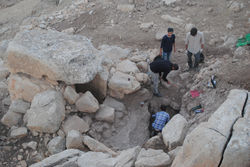
In order to better understand the chronological relationship between the town and the dolmens, it was decided to excavate dolmens located on the southern slope of the mountain, approximately 50 meters south of wall of the settlement.
The dolmens selected were nos 232, 228 and 318, all located lower of the village eastern enclosure. Some of the houses built outside the settlement are very close to the excavation area.
The excavation area consisted in three square of 5x5 m each around the dolmens. The total excavation area was of 30 square meters. Different layers covering the structures were identified. All the three dolmens are directly build on the bedrock, levelled by a layer of stones of small dimensions. The first results have been satisfactory. He has completed the excavation of three very interesting dolmens have provided extensive data and objects, with due study, help you understand the complicated field of Jebel Mutawwaq. It seems that the structures had been stripped funeral in ancient human remains that housed, and allowed only some minor debris such as broken bones.
The materials were indicative ceramic remains, maintaining both technical characteristics and decorative formal and identified with the Bronze Age. The lithic industry showed a lot of tools and scrapers made in silex.
Finally, we have documented stratigraphically different stages of construction, abandonment and, in some cases, reuse of dolmens. The topography was made by Ehab Jariri, Surveyor of the Department of Antiquities of Jordan. This map will be integrated into the MEGA project, the Jordanian Department.


